Unit - 2
Geomorphology and Historical Geology
Q1. Write short note on Endogenic and Exogenic processes?
A1. Endogenic Processes:The energy emitting from within the earth is the main force behind endogenic geomorphic processes. This energy is generated by radioactivity, rotational and tidal friction and primordial heat from the origin of the earth.
Exogenic Processes:Q2. What is Geological action by fluvial process i.e. river and Landforms formed it?
A2. During life while flowing from birth to end the river are capable of exerting greatly modifying influence over the topography of region through which they flow.
Geologic work of river divided into 2 group part:-
1. Erosion
2. Transportation
2. Deposition
These parts of geologic work cannot be separated one from the other, because where erosion occurs, there must be at least some transportation and eventually the transported particles must come to rest.
Erosion
Erosion means disintegration and decomposition of rocks and soil by natural agent through mechanical, and chemical action.
Types of erosion on overland flow responsible for geological action of river
1. Splash erosion: on barren soil surface, the impact of falling rain drops dislodges and moves the soil particles and called splash erosion.
2. Sheet erosion: on barren land due to deforestation, soil is removed by sheet erosion. By sheet flow and only bed rock remains.
Stream erosion is defined as the progressive removal of mineral matter from the surfaces of a stream channel. Stream produces many important and significant surface features along their channel directly and indirectly in the drainage basin some of these features develop with passage of time to form major geomorphologic landforms.
Stream erosion depends upon:-
A} materials of which the channel is composed and
b} means of erosion available to the stream.
There are 4 types of fluvial erosion described as below:-
1. Hydraulic action
2. Attrition
2. Corrosion or abrasion and
4. Corrosion
1. Hydraulic action is the force of the water itself. Weakly and loose consolidated bed rock and various forms of un cemented transported and residual overburden are readily worn away by hydraulic action alone, but this action has less impact on hard bonded bed rock.
2. Attrition is the disintegration which occurs when two or more particles which are suspended in water collide.
3. Abrasion: it occur when the impact of rock particles carried in the current striking
against the exposed bed rock of the channel surfaces. Most of the erosion done by a river is attributed to corrosive action. Due to this erosion following features are form chutes, plunge pools, potholes (cylindrical pit).
Potholes are generally cylindrical or bowl shaped .this holes are generally form in softer rock. Potholes are formed by simple plucking at river bed by hydraulic action.
4. Corrosion: It is the solvent action of river water. Chemical action between ions, occur in solution in stream water, and the exposed mineral surfaces result in a form of erosion known as corrosion.
TRANSPORATION
The load which a river carries is transported indifferent ways.
Sediments travel in 2 phases:-
1. Within the current (Finer particles are moved within the current)
2. Along the base of the current (Particles that do not become caught up within the turbulent eddies can be transported along the bottom of the current). They constitute the bed load.
The load which river carries is transported in four different ways:-
1. Traction
2. Saltation
2. Suspension
4. Solution
Traction: The rolling action of the coarsest particles along the river bed.
Saltation: Without being in suspended load, a particle may rise a few cm to as much as 20 cm above the bottom, travel down some distance, and them be pulled back by gravity. Such movement is called as saltation
Solution: Soluable material is carried in solution. Streams as environments for
depositing Sediments. A geologic agent that erodes and transports material can also function as a mechanism for depositing sediment. All stream deposited sediments are known as alluvium.4 environment settings from upstream areas to the
mouth of streams in which streams may deposit sediments are:
1. Fans (alluvial cone)
2. braided channels
2. Flood-plain rivers- Low land where channels form sweeping curves
Three major features of flood plain rivers are describe as below:-
1. The channel and its bordering low ridges composed of sediments
2. Meanders
2. The wide low lying flood plains (oxbow lakes) Levees width varies from 20m to several km. Height ranges from 10cm to meters
4. Deltas
DELTAIC ENVIRONMENT
the gathering of rivers with large water bodies large sediment cones,is known as deltas
now a day deltas are relatively young, as they have been formed only after the increased
sea level
The most important factors for the development of a delta are a large supply of sediments by streams and subsidence in the area of deposition. The ideal form of a delta is cone; this idea shape is seldom achieved.
STRUCTURE OF A DELTA
A delta is made up of
• Topset,
• Foreset and
• Bottomset deposits
Topset Deposits
Topset deposits of a delta are mainly made up of marsh deposits and delta front silts and sands.
Topset deposits can be differentiate into two parts:-
•Subaerial, and
•Subaqueous
Subaerial topset deposits are marsh and river channel deposits. Subaqueous topset deposits are delta front deposits, formed under the influence of fluvial processes.
Foreset Deposits
Foreset deposits are made up of pro-delta silty clays and rather coarse sand, silt, and clay deposits formed off the major deltaicn distributaries.
In the delta foresets, gullies are formed
Bottomset deposits are made up of offshore clays under the influence of active deltas.
Marginal Deposits
These are transitional deposits between bottomset deposits and the deposits of the subsurface, which were deposited before the building up of the delta.
Q3. What is Aeolian and glacial process?
A3. Aeolian processes
Aeolian landforms are create by the wind .Aeolian processes makes a number of distinct features, both erosion and deposition of sediment, including:
Aeolian processes include erosion, transportation, and deposition of sediment by the wind. All these processes take place in a variety of environments, including the coastal zone, cold and hot deserts, and agricultural fields. Features of these environments are infrequent or non-existent vegetation cover, a supply of fine sediment (clay, silt, and sand), and strong winds. Aeolian processes are in charge of for the emission or mobilization of dust and the formation of areas of sand dunes which largely depend on other geologic agents, such as rivers, glaciers, and waves, to supply sediment for transport.
Glaciers process
Glaciers makes the land through processes of erosion, weathering, transportation and deposition, creating different landforms.
Erosion
Types of erosion are:
Weathering
Freeze-thaw weathering is the foremost type of weathering. During the day when temperatures is high, the snow melts and water set foot in the cracks in the rock. When the temperature set below 0°C the water in the crack freezes and expands by about % .It makes the crack huge. As this process is repeated continuously through continual thawing and freezing the crack gets bigger over time. Eventually pieces of rock break off.
Glacial landforms created by deposition
The name given material accumulated by a glacier is called glacial till or boulder clay. Accumulated material creates a range of interesting features such as:
Processes of glacial transportation
The material transported by a glacier is called moraine. Three different types of moraine:
Terminal moraine - material accumulated at the end of the glacier
Q4. What is coastal geomorphology?
A4. The formation coastal geology consist of combination of processes, sediments, and the geology of the coast itself.
70% of Earth's surface is covered by water and the coast, which forms the interface between land and water.
For example movement and dissipation of large amounts of energy are done by waves and tides this energy are capable of causing rapid changes in landforms along coasts.
For protecting the shoreline and coastal zone with this energy barrier are provided such as reefs, and berms.
The coastal sizes and shapes ranges from gently sloping beaches to the high cliffs.
Coastal landforms are divided into 2 categories:
1. Erosional and
2. Depositional.
The overall nature of any coastal features are described in terms of above 2 categories.
Factors and forces in the formation of coastal features:-
The coast are the result of a combination of sediments and rocks present in coastal zone. The waves and the currents generate, along with tides. Climate and gravity are also some factor which affect formation of coastal features. The main features which leads to formation of coastal features are described as below:-
1. Waves
2. Long shore currents
3. Rip Current or rip tide
Other wave activity is the rip current. As waves move toward the beach, there is some net shoreward transport of water.
Rip current are generally classified as in 2 types:
(1) Shear instability rips and (2) flash rips
Water moves seaward through the surf zone in an effort to relieve the instability of the sloping water. Rip currents are of importance, as they carry a suspended load of fine sediment out from the shore. The seaward movement follow the narrow pathways. Generally rip tides are regularly spaced and flow at speeds of up to several tens of cm per sec. They can carry sediment and look a plume of suspended sediment moving out through the surf zone.
Q5. What is geological time scale?
A5.
1. Eons,
2. Eras,
2. Periods,
4. Epochs, and
5. Ages.
1. Eons:-
It is the largest intervals of geologic time and are hundreds of millions of years in duration. In the time scale above you can see the Phanerozoic Eon is the most recent eon and began more than 500 million years ago.
2. Eras:-
Important events in history of earth are used to found the boundaries of the eras. It is divided into smaller time intervals called as eras
3. Periods:-
Eras are subdivided into periods.
1. Epochs:-
Finer subdivisions of time are possible.
Example such as Cenozoic, periods subdivided into epochs.
Subdivision of periods into epochs can be done only for new or recent portion because old rocks have been buried deeply as compared to new rocks.

Q6. Explain physiographic division of India
A6. India can be divided into following physical divisions which are as follows:-
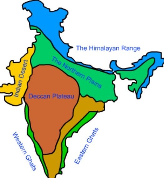
The Northern Mountains / Himalayan Mountains
1. Tropical,
2. Subtropical,
2. Temperate and
4. Alpine.
The Peninsular Plateau
1. The Central Highlands and
2. The Deccan Plateau.
The Central Highlands
The Deccan Plateau
The Indian Desert

The Coastal Plains
This plain lies from Arabian Sea on the west and along the Bay of Bengal on the east.
Western Coastal Plains

The Islands
Q7. What is the principle of stratigraphy
A7.
1) Atholic priest Nicholas Steno invented the theoretical basis for stratigraphy.
2) Stratigraphy is a branch of geology which study the rock layers (strata) and layering (stratification).
3) It is widely used in the study of sedimentary and layered volcanic rocks
4) Stratigraphy provide historical geology, and its principles
5) Startigraphy also used in method of petroleum geology and archaeology.
6) The principal in stratigraphy is that younger sediments are deposited on top of older sediments.
7) the patterns in which rock layers are deposited are given by Steno's laws of stratigraphy
8) the various law include in stratigraphy are as follows:-
Q8. Explain arcgean and dharwar formation?
A8. Archean’s & Dharwar formation
India has diverse geology. It contain rocks of all types which belongs to different geologic periods. Some of the rocks are badly disfigure and transmuted while others are recently accumulated alluvium that has yet to undergo diagenesis. Mineral deposits are found in the subcontinent in huge quantity. Structurally the Indian landmass is divided into three main divisions consisting of
However, it can be divided into several divisions such as Archean System, Dharwar System, Cudappah system, Vindhyan system, Paleozoic, Mesozoic, Gondwana, Deccan Trap, Tertiary and Alluvial.
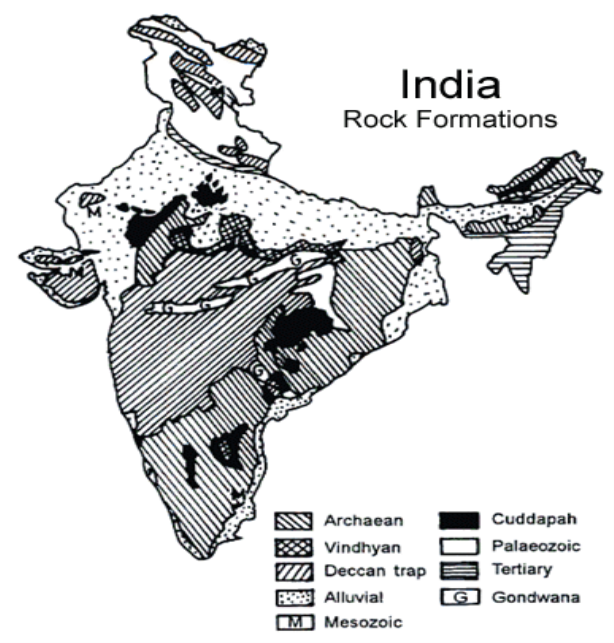
The other series of Dharwar system are as follows:
Q9. Explain cudappah system and vindhyan system?
A9. Cudappah SystemThey are rich in metamorphic rocks such as sandstone, shale, limestone, quartzite, and slate. It contain iron and other minor quality of ores and minerals. It is mainly found in Cudappah district of Andhra Pradesh, with other places such as Chhattisgarh, Rajasthan, Delhi, and the lesser Himalayas. Other important series of Cudappah System is Papaghani series, named after the river of name in Andhra Pradesh.
Vindhyan SystemThe Vindhyan Mountains lie between the Ganges plain and Deccan Plateau. The Vindyan system is named because of Vidhyan Mountains. The system rocks are extensively distributed in India from Chittorgarh (Rajasthan) to Sasaram (Bihar). The Vindhyan System is separated from Aravallis by the Great Boundary Fault. It is famous sources of Red Sandstone and other building material. Panna and Golconda diamonds are found in this formation. The other series of this
Q10. What are the Significance of their structural characters in major civil engineering activities?
A10. The various significant of historical geology in civil engineering are as follows:-