Unit - 2
Geomorphology and Historical Geology
Q1) Write short note on Endogenic and Exogenic processes?
A1) Endogenic Processes:
The energy emitting from within the earth is the main force behind endogenic geomorphic processes. This energy is generated by radioactivity, rotational and tidal friction and primordial heat from the origin of the earth.
Exogenic Processes:
Exogenic processes get the energy from atmosphere control by the ultimate energy from the sun and the gradients created by tectonic factors. Gravitational force acts upon all earth materials a sloping surface which tend to produce movement of matter in down slope direction. Force applied per unit area is called stress. It is produced in a solid by pushing or pulling which induces deformation.
Forces acting across the faces of earth materials are shear stresses (separating forces), stress which breaks rocks and other earth materials. All the exogenic geomorphic processes are covered under a general term, denudation.
Word ‘denude’ means to uncover. Weathering, mass wasting/ movements, erosion and transportation included in denudation. As there are different climatic regions on the earth’s surface owing, the exogenic geomorphic processes changes from region to region
Q2) What is Geological action by fluvial process i.e. river and Landforms formed it?
A2) During life while flowing from birth to end the river are capable of exerting greatly modifying influence over the topography of region through which they flow.
Geologic work of river divided into 2 group part:-
1. Erosion
2. Transportation
3. Deposition
These parts of geologic work cannot be separated one from the other, because where erosion occurs, there must be at least some transportation and eventually the transported particles must come to rest.
Erosion
Erosion means disintegration and decomposition of rocks and soil by natural agent through mechanical, and chemical action.
Types of erosion on overland flow responsible for geological action of river
1. Splash erosion: on barren soil surface, the impact of falling rain drops dislodges and moves the soil particles and called splash erosion.
2. Sheet erosion: on barren land due to deforestation, soil is removed by sheet erosion. By sheet flow and only bed rock remains.
Stream erosion is defined as the progressive removal of mineral matter from the surfaces of a stream channel. Stream produces many important and significant surface features along their channel directly and indirectly in the drainage basin some of these features develop with passage of time to form major geomorphologic landforms.
Stream erosion depends upon:-
A} materials of which the channel is composed and
b} means of erosion available to the stream.
There are 4 types of fluvial erosion described as below:-
1. Hydraulic action
2. Attrition
3. Corrosion or abrasion and
4. Corrosion
1. Hydraulic action is the force of the water itself. Weakly and loose consolidated bed rock and various forms of un cemented transported and residual overburden are readily worn away by hydraulic action alone, but this action has less impact on hard bonded bed rock.
2. Attrition is the disintegration which occurs when two or more particles which are suspended in water collide.
3. Abrasion: it occur when the impact of rock particles carried in the current striking
against the exposed bed rock of the channel surfaces. Most of the erosion done by a river is attributed to corrosive action. Due to this erosion following features are form chutes, plunge pools, potholes (cylindrical pit).
Potholes are generally cylindrical or bowl shaped .this holes are generally form in softer rock. Potholes are formed by simple plucking at river bed by hydraulic action.
4. Corrosion: It is the solvent action of river water. Chemical action between ions, occur in solution in stream water, and the exposed mineral surfaces result in a form of erosion known as corrosion.
TRANSPORATION
The load which a river carries is transported indifferent ways.
Sediments travel in 2 phases:-
1. Within the current (Finer particles are moved within the current)
2. Along the base of the current (Particles that do not become caught up within the turbulent eddies can be transported along the bottom of the current). They constitute the bed load.
The load which river carries is transported in four different ways:-
1. Traction
2. Saltation
3. Suspension
4. Solution
Traction: The rolling action of the coarsest particles along the river bed.
Saltation: Without being in suspended load, a particle may rise a few cm to as much as 20 cm above the bottom, travel down some distance, and them be pulled back by gravity. Such movement is called as saltation
Solution: Soluable material is carried in solution. Streams as environments for
depositing Sediments. A geologic agent that erodes and transports material can also function as a mechanism for depositing sediment. All stream deposited sediments are known as alluvium.4 environment settings from upstream areas to the
mouth of streams in which streams may deposit sediments are:
1. Fans (alluvial cone)
2. braided channels
3. Flood-plain rivers- Low land where channels form sweeping curves
Three major features of flood plain rivers are describe as below:-
1. The channel and its bordering low ridges composed of sediments
2. Meanders
3. The wide low lying flood plains (oxbow lakes) Levees width varies from 20m to several km. Height ranges from 10cm to meters
4. Deltas
DELTAIC ENVIRONMENT
The gathering of rivers with large water bodies large sediment cones,is known as deltas
Now a day deltas are relatively young, as they have been formed only after the increased sea level
The most important factors for the development of a delta are a large supply of sediments by streams and subsidence in the area of deposition. The ideal form of a delta is cone; this idea shape is seldom achieved.
STRUCTURE OF A DELTA
A delta is made up of
• Topset
• Forest
• Bottomset deposits
Topset Deposits
Topset deposits of a delta are mainly made up of marsh deposits and delta front silts and sands.
Top set deposits can be differentiating into two parts:
• Subaerial, and
• Subaqueous
Subaerial topset deposits are marsh and river channel deposits. Subaqueous topset deposits are delta front deposits, formed under the influence of fluvial processes.
Forest Deposits
Fore set deposits are made up of pro-delta salty clays and rather coarse sand, silt, and clay deposits formed off the major deltaic distributaries. In the delta forests, gullies are formed
Bottomset deposits are made up of offshore clays under the influence of active deltas.
Marginal Deposits
These are transitional deposits between bottomset deposits and the deposits of the subsurface, which were deposited before the building up of the delta.
Q3) What is Aeolian and glacial process?
A3) Aeolian processes
Aeolian landforms are created by the wind. Aeolian processes makes a number of distinct features, both erosion and deposition of sediment, including:
• Sand dunes
• Loess Deposits
• Ventifact
• Yardangs
• Deflation Hollow or Blowout
• Desert Pavement
Aeolian processes include erosion, transportation, and deposition of sediment by the wind. All these processes take place in a variety of environments, including the coastal zone, cold and hot deserts, and agricultural fields. Features of these environments are infrequent or non-existent vegetation cover, a supply of fine sediment (clay, silt, and sand), and strong winds. Aeolian processes are in charge of for the emission or mobilization of dust and the formation of areas of sand dunes which largely depend on other geologic agents, such as rivers, glaciers, and waves, to supply sediment for transport.
Glaciers process
Glaciers makes the land through processes of erosion, weathering, transportation and deposition, creating different landforms.
Erosion
Types of erosion are:
Abrasion – It is the glacier which moves downhill, rocks that have been frozen into the base and sides of the glacier scrape the rock underneath. The rocks scrape the bedrock like sandpaper, leaving scratches called striations behind.
Plucking –In plucking the rocks become frozen into the base and edges of the glacier. As the glacier moves downhill it 'plucks' the rocks frozen into the glacier from the ground.
Weathering
Freeze-thaw weathering is the foremost type of weathering. During the day when temperatures is high, the snow melts and water set foot in the cracks in the rock. When the temperature set below 0°C the water in the crack freezes and expands by about %. It makes the crack huge. As this process is repeated continuously through continual thawing and freezing the crack gets bigger over time. Eventually pieces of rock break off.
Glacial landforms created by deposition
The name given material accumulated by a glacier is called glacial till or boulder clay. Accumulated material creates a range of interesting features such as:
Erratics–It is the rock which is deposited by the glacier. It is made of a rock type that would not be found in that area which suggests that erratics can be move a long way from an area of different geology.
Drumlins - glaciers can move moraine around in abnormal ways which produce interesting features. Drumlins are mounds of accumulated moraine. It has a steep side and a sloping side. It is also called a 'basket of eggs' topography because of the unusual landscape they create.
Processes of glacial transportation
As freeze-thaw weathering happens along the side of the glacier pieces of rock, which break off larger rocks, fall into the glacier and are moved.
Rocks plucked from the base and sides of the glacier are transported downhill with the ice.
Rotational slip is the annular movement of the ice in the corrie.
The material transported by a glacier is called moraine. Three different types of moraine:
Lateral moraine - material deposited along both edges of the glacier.
Medial moraine - material deposited in the middle of the glacier. It is caused by the sidewise moraines of two glaciers when they meet.
Terminal moraine - material accumulated at the end of the glacier
Q4) What is coastal geomorphology?
A4) The formation coastal geology consists of combination of processes, sediments, and the geology of the coast itself.
70% of Earth's surface is covered by water and the coast, which forms the interface between land and water.
For example, movement and dissipation of large amounts of energy are done by waves and tides this energy are capable of causing rapid changes in landforms along coasts.
For protecting the shoreline and coastal zone with this energy barrier are provided such as reefs, and berms.
The coastal sizes and shapes range from gently sloping beaches to the high cliffs.
Coastal landforms are divided into 2 categories:
1. Erosional and
2. Depositional.
The overall nature of any coastal features are described in terms of above 2 categories.
Factors and forces in the formation of coastal features: -
The coast are the result of a combination of sediments and rocks present in coastal zone. The waves and the currents generate, along with tides. Climate and gravity are also some factors which affect formation of coastal features. The main features which lead to formation of coastal features are described as below: -
Waves
The waves moving toward the beach in continuous form result into formation of coast. Waves depend upon various factor and also differ from place to place.
The larger waves bring out more particle that can be moved. Larger waves, generally forms during storms, which are responsible for the removal of sediment from the coast
Small waves also bring out sediments from ocean depth here small waves means 10cm high. Cobbles and rock material with high wave sometimes bring out by ocean. Waves interact with the bottom of ocean as they travel into shallow water depth this cause sediment to become suspended for some extent of time. Small waves generally consist of sediment and sand which are transported toward the coast and are deposited on the beach.
Waves erode the rock bed along the coast largely by the force called as abrasion.
Waves have huge force and that may break up bedrock by impact load. The suspended sediment particles in waves from ocean, pebbles and rock debris, have the same effect on a surface of coast.
Long shore currents
Waves generally reaches towards the coast at acute angle rather than exactly parallel to it. Due to these waves are bent as they enter shallow water, which forms a current along the shore and parallel to it. Such a current is defined as long shore current, and it is stretch out from the shoreline out through the area of breaking waves.
The speed of the current depends upon the size of the waves and their angle of reaching. Long shore currents move only about 10–20 m per sec but, at stormy conditions they may exceed 1 metre per sec.
Long shore currents are caused due to approaching and refracting waves, they may move in either direction along the coast, depending on the wave direction.
Although a long shore current can entrain sediment if it moves fast enough, waves typically cause sediment to be picked up from the bottom, and the long shore current transports it along the coast.
The waves and long shore both combined to carry or transport large quantities of sediment along the shallow zone adjacent to the shoreline.
This direction of approach is governed by the wind direction, which is therefore the ultimate factor in determining the direction of long shore currents and the transport of sediment along beach.
Rip Current or rip tide
Other wave activity is the rip current. As waves move toward the beach, there is some net shoreward transport of water.
Rip current are generally classified as in 2 types:
(1) Shear instability rips and (2) flash rips
Water moves seaward through the surf zone in an effort to relieve the instability of the sloping water. Rip currents are of importance, as they carry a suspended load of fine sediment out from the shore. The seaward movement follow the narrow pathways. Generally rip tides are regularly spaced and flow at speeds of up to several tens of cm per sec. They can carry sediment and look a plume of suspended sediment moving out through the surf zone.
Q5) What is geological time scale?
A5)
Geologic time scale is an important aspect in geology used to find out the history of the Earth or it is also defined as standard timeline used to find the life or age of rocks and fossils.
Or simply geologic time scale is the “calendar” for events in history of earth
Geologic time scale was basically to find duration of each time unit.
Geologists have divided history of earth into some series of time intervals. Geologic time is divided using important events in the history if they occur. Like Eons are divided into smaller time intervals called as eras.
Event are subdivides all time into named units of time called—according to duration at decreasing order that are described as below: -
1. Eons: -
It is the largest intervals of geologic time and are hundreds of millions of years in duration. In the time scale above you can see the Phanerozoic Eon is the most recent eon and began more than 500 million years ago.
2. Eras: -
Important events in history of earth are used to found the boundaries of the eras. It is divided into smaller time intervals called as eras
3. Periods: -
Eras are subdivided into periods.
4. Epochs: -
Finer subdivisions of time are possible.
Example such as Cenozoic, periods subdivided into epochs.
Subdivision of periods into epochs can be done only for new or recent portion because old rocks have been buried deeply as compared to new rocks.

Q6) Explain physiographic division of India
A6) India can be divided into following physical divisions which are as follows:-
The Northern Mountains
The North Indian Plain
The Peninsular Plateau
Great Indian Desert
The coastal Regions
Islands

The Northern Mountains / Himalayan Mountains
Young mountains which cover the northern borders of India
It prolong from west to east direction from the Indus to the Brahmaputra river
It prevent the entry of cold air entering into India and it also helps in precipitation of rain and snow in India by acting as barrier.
In this northern mountain out of 100%, 80% population live in rural areas and 20% live in urban areas.
It cover a distance of 2,400 Km in length at arc with varying width from 400 Km in Kashmir to 160 Km Arunachal Pradesh
eastern part altitudinal variations are greater than in the western part
Over 52% of total area of the Indian Himalayan region is covered by forests.
Himalayan vegetation can be subdivided into four types –
1. Tropical,
2. Subtropical,
2. Temperate and
4. Alpine.
The Himalayas act as a great climatic divide affecting large systems of air and water circulation.
Animal like Asiatic black bears, langurs, Himalayan goats, and Indian rhinoceros are found in this area or mountain.
The south-facing slopes of northern Mountain have a fairly thick soil cover in forest.
The soils colour is dark brown and texture is loamy and the soils are deficient in humus content at high altitudes.
The Peninsular Plateau
The features of this plateau are shallow and broad.
The plateau is triangular in shape and covered by hills, and formed with the Gondwana land.
The plateau is divided into two regions,
1. The Central Highlands and
2. The Deccan Plateau.
The Central Highlands
The Central Highlands lies to the north of the Narmada River
It is wider in the west and narrower in the east.
covers the major portion of the Malwa plateau
The slope of this region is that river flow from southwest to northeast
Bundelkhand and Baghelkhand are the eastward extension of the central highland.
The plateau is extends eastwards into the Chhotanagpur plateau
The Deccan Plateau
Deccan plateau lies in between two mountain ranges which arethe Western Ghats and the Eastern Ghats.
Each rises from its respective nearby coastal plain almost meet at the southern tip of India.
The average elevation of Eastern Ghats is 600meter.
The average elevation of Western Ghats is 900 – 1600 metre
This plateau is the largest in India lies to south of Narmada river
The shape is like pointing triangle downward.
It is divided from the Gangetic plain to the north by the Satpura ranges and Vindhya Ranges, which form its northern boundary
This zone is suitable for cotton cultivation
The Indian Desert
The Indian desert lies towards the western margins of the Aravali Hills.
the climate is arid
Vegetation is scanty in this zone.
Rainfall which is less than 150 mm annually in this region.
River luni is only prominent river in this zone.

The Coastal Plains
This plain lies from Arabian Sea on the west and along the Bay of Bengal on the east.
Western Coastal Plains
The Western Coastal plain lies 50 kilometres in width
counterpart, between the west coast of India and the Western Ghats hills, which starts near the south of river Tapi
These plains start from Gujarat in the north and end at Kerala in the south.
It includes following states of Maharashtra, Goa and Karnataka
On the northern part of this coast Gulf of Kutch and the Gulf of Khambat lies.
Western coastal plane is mainly divided into following part: -
Kutch to Daman (Tapti, Narmada, Sabarmati & Mahi river) the coast is Kathiawar
Between Daman & Goa the coast is Konkan
Between Goa to Cannanore the coast is Kannada
Between Cannanore to Cape Camorin the coast is Kanyakumari.
Malabar coast à Kannada Coast + Kanyakumari Coast

Eastern Coastal Plains
The Eastern Ghats and the Bay of Bengal are called as eastern coast.
It consists from Tamil Nadu in the south to West Bengal in the north.
These plains are wider than western coast.
Eastern coastal plane is mainly divided into following sections
Deltaic plains of Ganga to Mahanadi delta (Chilka lake of Orissa is located in this plain) this coast is called as Utkal
Utkal plains to Pulicat Lake (deltas of Godavari & Krishna Rivers, & Kolleru Lake) the coast is called as Andhra.
Utkal Coast + Andhra Coast (in between Mahanadi & Krishna) the coast is called as northern circars
Between Krishna & Kanyakumari (Kaveri Delta) the coast is called as Coromandal.
The Islands
Total number of islands in India 247
Where 204 is in Bay of Bengal and 42 in Arabian sea
Some coral islands are also in Gulf of mannar.
Largest islands of India are middle Andaman and Nicobar Islands
The Indira point is the Southern-most point of India which is in Nicobar Island
Lakshadweep islands in the Arabian Sea which are formed by corals reefs.
Indira point was called Pygmalion Point earlier.
Q7) What is the principle of stratigraphy
A7)
Atholic priest Nicholas Steno invented the theoretical basis for stratigraphy.
Stratigraphy is a branch of geology which study the rock layers (strata) and layering (stratification).
It is widely used in the study of sedimentary and layered volcanic rocks
Stratigraphy provides historical geology, and its principles
Startigraphy also used in method of petroleum geology and archaeology.
The principal in stratigraphy is that younger sediments are deposited on top of older sediments.
the patterns in which rock layers are deposited are given by Steno's laws of stratigraphy
the various law include in stratigraphy are as follows: -
Law of uniformitartanianism given by James Hutton (1726-1729)
Law of lateral continuity given by Nicholas Steno in 1628-1686- its state that sediment strata are lies in layer and that are nearly horizontal and parallel to surface of earth.
Law of inclusions –it means a rock fragment enclosed within another rock is said to be an inclusion.
Law of superposition given by Nicholas stenoin 1667-is state that younger sedimentary layer lies over older ones.
law of cross-cutting relationships given by Nicholas steno in 1669 but later formulated by james huto in 1795-its state that younger features are cut across the older features
Law of chilled margins-chilled margins younger than surrounding rock because the surrounding rocks had to cooled first.
Correlation –it finds out the time equivalency of rock units. Rock units are correlated with a region, continent, and even between continents.
Q8) Explain arcgean and dharwar formation?
A8) Archean’s & Dharwar formation
India has diverse geology. It contains rocks of all types which belongs to different geologic periods. Some of the rocks are badly disfigure and transmuted while others are recently accumulated alluvium that has yet to undergo diagenesis. Mineral deposits are found in the subcontinent in huge quantity. Structurally the Indian landmass is divided into three main divisions consisting of
The Himalayan Mountain Chain
The North Indian Plain; and
The Peninsular Plateau.
However, it can be divided into several divisions such as Archean System, Dharwar System, Cudappah system, Vindhyan system, Paleozoic, Mesozoic, Gondwana, Deccan Trap, Tertiary and Alluvial.
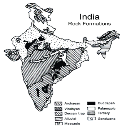
Archean formations
Archean rocks, also called as Pre-Cambrian rocks are the oldest rocks of the earth’s crust. The Archean period covers 86.7% of Total geological history time of earth. This interval marks the development of first photosynthesis, the life support atmosphere.
The major particular of the Archean rocks is that they are azoid. They serve as the basement network or fundamental gneisses.
The Archean rocks in India are called Purana Rocks. These rocks are rich in metallic and non-metallic minerals such as iron, copper, manganese, bauxite, lead, zinc, gold, silver, tin, tungsten, mica, asbestos, graphite, etc.
Dharwar system
Dharwar system is newer than the Archean system but senior than the other systems. The Dharwar period of rock development has been largely fixed from 2500 million years ago to 1800 million years ago. Dharwar Rock System is special because it is the first metamorphic sedimentaryrocksin India.
It is called Dharwar system because it is first studied in Dharwar region of Karnataka. Also found in Aravallis, Tamil Nadu, Chotanagpur plateau, Meghalaya, Delhi, and the Himalayas region.
The Dharwar rocks are abundant in iron ore, manganese, lead, zinc, gold, silver etc.
The Champions series include gold mines lie in this system. This Champion system is named after the Champion reef in the Kolar Gold Fields. The Kolar Gold Field carry one of the deepest gold mines of world.
The other series of Dharwar system are as follows:
Champaner series that is found near Baroda. It is green variety of marble.
Closepet series which is found in Balaghat and Chhindwara of Madhya Pradesh. It is abundant in copper ores.
Chilpi Series which is found in and around the Closepet series in Balaghat and Chhindwara
Iron-Ore series which is located in Singhbhum, Mayurbnhanj and Keonjharrangaes.
Q9) Explain cudappah system and vindhyan system?
A9) Cudappah System
They are rich in metamorphic rocks such as sandstone, shale, limestone, quartzite, and slate. It contains iron and other minor quality of ores and minerals. It is mainly found in Cudappah district of Andhra Pradesh, with other places such as Chhattisgarh, Rajasthan, Delhi, and the lesser Himalayas. Other important series of Cudappah System is Papaghani series, named after the river of name in Andhra Pradesh.
Vindhyan System
The Vindhyan Mountains lie between the Ganges plain and Deccan Plateau. The Vindyan system is named because of Vidhyan Mountains. The system rocks are extensively distributed in India from Chittorgarh (Rajasthan) to Sasaram (Bihar). The Vindhyan System is separated from Aravallis by the Great Boundary Fault. It is famous sources of Red Sandstone and other building material. Panna and Golconda diamonds are found in this formation. The other series of this
Q10) What are the Significance of their structural characters in major civil engineering activities?
A10) The various significant of historical geology in civil engineering are as follows: -
• To find out the ground water table
• It gives an idea about materials used for construction
• Helpful for river control and shipping work.
• Soil tests are done before any project.
• for constructing dams
• Geotechnical engineers need knowledge about this subject for digging work.
• To find out foundation faults.
• For design of highways and roads.
• Tunnel construction
• Economical design is advanced.
• To identify the earth quake prone areas.